photograph by Jamie West McGiver
Hiking, swimming and killer views—this Lake George trek has it all
It’s the backside of a gargantuan dragon. The head is miles north, up in the heights, and the spine ripples and bumps down over huge bony plates to the tail, whose tip points far south and lies still in the water. This was my first impression of the Tongue Mountain Range on Lake George. Whoever named it viewed it as an oral appendage, but I see all dynamic reptile here.
Today in early June is for dual adventures on Tongue: first, to trek the lower half of its roller-coaster spine, and second, to wander its quiet west flank, looking for good swim spots along the lake’s Northwest Bay. The day will be huge, and this landscape is too: within the park, Lake George is its largest water body; Tongue, its longest wild peninsula; and Northwest, its biggest bay. They are respectively 32, 11 and three miles long.
The trailhead is called Clay Meadows, named for the meandering silty delta the trail first crosses, but the start is anything but lazy. Parking is squeezed at a granite quarry of hard rock cuts, with the first hundred yards’ walk pinched along the shoulder of 9N, vehicles whizzing by. Even though the trail quickly departs this harsh stint, the contrast befits the day. My hike will be both tough and mellow.
Back to reptiles. Rattlesnakes live here on Tongue, but a flyer in the trail register box simply tells hikers to be alert and careful. The eastern timber rattler, alarmingly named Crotalus horridus, is truly nonaggressive and retiring. In eight trips here, I’ve not chanced on one; they prefer retreat to attack.
But another creature is all over the place: beavers are at it on Northwest Bay Brook, plugging its flow and slowing its meanders. They’re considered a “keystone” species, creating watering hole habitats for others that come to drink, hide or eat. It’s an intricate food web at this haven, not far from the road.
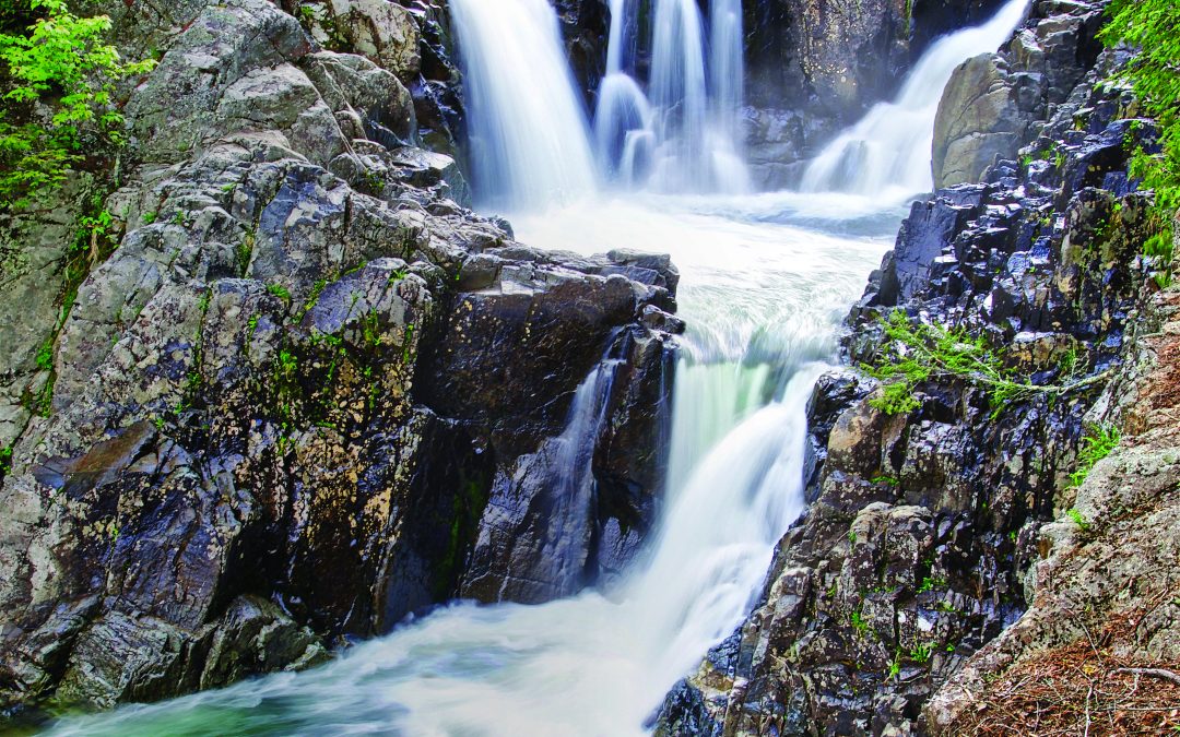
Onto dry land, the trail forks into rugged and gentler branches. I head left toward the rollicking ridgeback and will come back on the milder shoreline path to my right. In the 1930s, the Civilian Conservation Corps (CCC) built these as horse trails. The bridges and rock walls show a level of stonework rarely attained these days. Solid bridge abutments and switchback retaining walls mark off the steady uphill way; the day’s biggest stream pours over mossy chunks of granite.
It’s 30 minutes of huffing to hit the ridge trail, though the junction with it, already five miles out the spine of the range, is deep in the Saddle, a low point between Five Mile Mountain and Fifth Peak. So, I have more uphill to the lean-to on the latter summit, the first of the day’s 15 ridge-top humps. Here, a small meadow tenders twin prospects, east over the lake below and west to Gore Mountain and higher ridges. Lots of hikers reach this spot, but few head farther out along the rough spine.
The south side of the peak is cliffy and steep, as are all of Tongue’s dragon bumps. Ages ago, violent geology shifted and dropped the land, leaving these sheer fault-created bluffs. Scientifically, this is a “graben,” German for “dig,” as in trench or grave. Some of the downhills are very hairy, with a misstep likely causing a plunge. In the reptile motif, these feel more like the bony plates of a stegosaurus’s back—sharply up-down, up-down. My knees are getting a huge workout.
Not all of Tongue’s bumps are named, but all that are have killer views. Each looks south along the ridge, or east or west. Water and woody knobs are always in sight. The plateau of French Point Mountain looks back north along the lake and plunges down to The Narrows, chock-full of islands. I dangle my legs over the edge, agog at the vista.
There are flat stretches in between, and in the springtime water collects in some of them. Below Fifth Peak, on the way down to First Peak, I come upon a small vernal pool. These tiny ponds lack a steady inflow of water, so fish can’t breed in them; they’re fairly safe nurseries for invertebrates and amphibians. Caddisflies, dragonflies, wood frogs, toads and blue-spotted salamanders are some of their natives. Wood ducks visit, and raccoons, mink and wading birds feed. Vernal pools are exceptional and fleeting refuges; this one was no more than 50 feet across. By summer, it will likely be gone.
There was a fire atop First Peak in August 2015; from a nearby ridge, I’d watched a helicopter shuttle water from the lake as smoke plumed into a hazy sky. Up close, it’s a scene of orderly destruction. The summit is cleared down to short stumps—probably as a landing field for the ’copter —and those trees are heaped below the lookout. The standing ones are charred but leafed-out. The fire seems to have been readily contained. Over the years, it will be intriguing to watch First Peak recover.
Even though it’s the first named peak along Tongue’s ridge, there are still more bumps, views and steeps below it. But my perspective on the lake changes from far above, to just above. I’m tiring as I reach the fork with the Northwest Bay trail, my lake-level route back. First I head out to the tip, a five-minute walk, for a dip. But there’s yet another uphill—just a mere 20-foot ripple in the dragon’s tail—before it finally drops into the water.
The Point of Tongue, also called Montcalm Point, is rarely quiet: boats zoom, chug, thunder and whine by this mid-lake headland. It must have also been raucous here in August 1757, amidst the French and Indian War, when the French commander, General Montcalm, cruised south with 8,000 troops—including a huge number of Indian and Canadian allies—to attack Fort William Henry. They sacked the fort, but the Brits soon retook it, and a year later sailed north with 16,000 of their own, trying to snag the then-French fort at Ticonderoga. Back-and-forth it went. This was the water highway connecting the Hudson and St. Lawrence, long embattled for control of eastern North America. As sway over the lake changed, so did its name: first, it was the Mohawk Andia-ta-roc-te, next the French Lac du Saint Sacrement, then the British for their King George II. Maybe today’s noisome traffic isn’t so harsh.
I only dunk my feet at the rocky shore and turn back along the bay trail, wanting more calm than at Montcalm.Close by, Northwest Bay is the quietest part of the lake. There’s a lovely stretch of dipping places about halfway up the bay. I head north by Northwest.
The trail is mostly at lake level, but twice it veers uphill to avoid a pair of shoreline camps. There used to be more, but in the 1920s most of the private parcels were sold or given to the state to thwart plans for a 14-mile long shoreline highway. Tongue Mountain Range is now 99 percent protected, and road-free.
The trail also wings away from the water to skirt some small bays. These little backwaters are stream-fed, quiet grassy refuges for frogs, toads and minnows, away from the wakes and waves.
One more stream crossing and I’m at the swim spots. This is a half-mile of shoreline with several wonderful dipping places. A pair of these are mellow grass-to-sand water entries, and a couple are rocky dive-or-jump ledges.
The entire stretch is visible from the mossy brook at its south end and also from Bear Point at the north; you could make a day of it and shuttle between them all and picnic at your favorite. I choose a mellow entry, sit down and scoot into deeper water, letting my muscles go. This is near the head of Northwest Bay, and it’s pretty tranquil.
With a short snooze and dry-off in the sun, I’m on my way for the final stretch. The CCC rockwork takes over again, and the trail gets the feel of a small roadway. During construction, when the rattlesnakes were discovered, the horse trail scheme was abandoned; those two creatures do not mix.
The trail takes one last detour from the shore, which is now a marshy inlet along lower Northwest Bay Brook. It’s a significant uphill to a stream crossing and then a steep-ish drop back to the brook. The sun is low now, even on a long June day, and the forest is silent.
I reach my first and last trail fork, the one that brought me from the car to the ridge. I’ve seen no hikers since the lean-to up there—strange for such a remarkable mountain. But it’s a tough jaunt over the dragon’s spine. The bay trail is almost as secluded, but gentler, with the sweet spots for splashing about.
Even the highway is quiet as I get back to the truck. It has been a huge day, with much to savor. From the rugged trek above sweeping lake vistas, to the long winding ramble by the water, Tongue has it all. I plop into the driver’s seat and leave the place to the locals—the beavers, bears, snakes, frogs and all the others who are bedding down for the night, somewhere on the big sleeping dragon.
If You Go:
For the ridge: Have at least eight hours, stamina, tough knees, lots of water, food, 7.5′ Shelving Rock or Bolton Landing 15′ quad map or GPS (may show less detail), sturdy broken-in footwear, first-aid kit, cell phone, non-cotton layers, hat, sunscreen. (Optional: binoculars, camera, field guides.) 1.6 miles from the trailhead to the junction with the ridge trail turning right; to Fifth Peak lean-to cutoff, 2 miles; to French Point Mountain, 3.9 miles; to Montcalm Point, 7.2 miles; back along Northwest Bay Trail to the half-mile of swim spots, 10.2–10.7 miles; to Clay Meadow trailhead, 12.7 miles.
For the swim: Allow at least four hours, and same as above plus towels. (Take a right at the first fork on the trail and go 2–2.5 miles to get to the half-mile of swim spots.)
David Thomas-Train is the editor of the fourth edition of the Adirondack Mountain Club’s Eastern Trails guide.
He lives in Keene Valley.