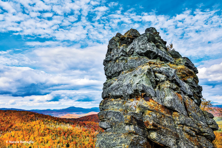
Pine Orchard photograph by Carl Heilman II
On the trail with guidebook author David Thomas-Train
Here are four of the 140 destinations in Eastern Trails, the Adirondack Mountain Club guidebook I author. Over five editions, the list’s grown from 87. I’ve only been on board part of the way, but I’ve also grown—in fondness for this range of places, from the hub-bubbed Lake George shores to the hushed reaches of Hamilton County. It’s been a labor and journey of love.
Coot Hill
Hovering hawks, trysting teens, glacial gouging, killing kin? An unlikely quartet, except at Coot Hill, south of Port Henry, which is rife with history—human and wild. At first glance, this hike looks not so rousing: a middling approach on a rutty and sometimes trash-strewn road. But the closer you get, the more you take in, you find that forecast’s dead wrong.
From my High Peaks home, Coot Hill’s the nearest and dearest hike for me in Eastern Trails, a 25-mile drive into the guidebook’s gentler, more varied terrain. The book’s footprint covers a couple of big rectangles down to and west of Lake George. For someone weaned on the Forty-Six, it’s a brave new world.
Head to Port Henry on Lake Champlain and ascend a thousand feet to Lang Road. At the edge of the Adirondack dome, we’re about as far east as we can get. After a few small farms, the forest takes over, and then, like much of this part of the Adirondacks, we’re in a 19th-century iron-mining neighborhood.
That early community held about 80 houses, three schools and several forges. The road heads in a mile east, past a few current dwellings, cellar holes and hunting camps. You can drive the bumpy mile, but I like to walk it to get a feel for this neck of the woods. First stop is Lang Cemetery.
It’s a tiny, secluded last resting place. Flags and medallions honor the graves of veterans, one from the Revolution. Several Langs lie under the lumpy turf, yet I’m most taken with the cracked headstone of “Leafy Winters, Wife of Ashley Woods”—such tender sylvan names in this shady corner of a long-gone hardscrabble hamlet, buried with their little Minerva, named after the Roman goddess of wisdom.
From here, it is on foot, as the road wallows in mud and then creaks its way up a rocky spine to the lookout. The ground falls away on both sides—east to the Champlain Valley, south into Big Hollow, a 400-foot glacial chasm. Robert Rogers, the 18th-century British guerrilla fighter, spied from the lookout onto the French fort below at Crown Point.
Farm fields stretch to the lake and beyond to the Green Mountains. Cliffs tumble into talus heaps pierced by cedars down in the gulf. Blueberries, sweet fern and juniper abound up here.
So do raptors. Coot Hill’s long been a hawk-watching mecca, fall and spring, as petite kestrels to jumbo eagles wing the thermals south and back north. I’ve also spotted sharp-shins, peregrines, red tails and ospreys gliding and zooming about.
Popular and accessible though the place is, it used to be more so. One hundred and fifty years ago, a tourist draw called Grandview perched atop Bulwagga Mountain across the ravine. A stagecoach brought crowds up to a dance hall and viewing pavilions for parties and church meetings. But tragedies struck: a horse and buggy plunged off the brink; the owner shot himself and his wife. Sightseeing withered and the neighborhood re-wilded.
Coot Hill is private land, but its owner kindly allows hikers in, and she expects us to care for the place. This did not always happen back when the road in was fully accessible and it was a local make-out spot.
One dark and steamy night here in the 1990s, a young couple was distractedly engaged in their vehicle when its emergency brake disengaged, and over the lip they plunged. Luckily, the trees halted their tumble, but unluckily onto a bees’ nest. The tormented pair extricated and hoofed it in the raw to the nearest house for help.
Visit Coot Hill, gawk at the hawks, watch your step, be mindful of the birds and the bees. The long round-trip hike in is three miles; the short version, just one.
If You Go
From the center of Port Henry, drive south on South Main Street for 1 mile. Turn right on Edgemont Road and follow it for 1.5 miles. Turn left on Harry Allen Road; follow it for 0.8 mile to County Route 7 (South Moriah Road). Turn left and drive for 0.8 mile to Lang Road. Turn left on Lang Road, a small rough-and-tumble dirt route, and park on the right shoulder after the last house, which is on the left, at 0.6 mile. Or drive 1.6 miles to Lang Cemetery, and park at the tiny graveyard on the right.
Chestertown Eight
Moving south there’s a mix of destinations: town trail systems, an abandoned manor, lengthy backcountry hikes, former farmland, nature centers, fire-tower peaks, remote bushwhacks and more than a dozen private preserves.
A highlight, anchored in Chestertown, is the Chester Challenge, eight mini-treks circling that village. They range from a half to a couple miles on public and private land; four are small mountains, two are mellow trail webs, and one each is a striking wetland and a pond.
Each summit’s got a catching vista with a viewfinder that tags prominent spots visible from up top; all are on private land and subject to landowner rules. Meade and Beckman Mountains are a steep half-hour huff and puff to their twin crests, Kipp likewise to its piney cliff-top perch, while Stewart’s a 10-minute jaunt to its lookout.
Three trails—Chester Creek, Cougar and Dynamite Hill—are close to the town center, rambling along hillside woods and a wetland on community byways.
Palmer Pond is the longest tramp—two miles of gentle woods roads into an appealing water body on Forest Preserve land west of town. It has the most backcountry feel of the eight.
North Country town trails and hiking challenges are a bright initiative of the last decade, designed to lure visitors and locals outdoors. This network is a joint effort of the town and Glens Falls Hospital.
If You Go
Each route has its own trail markers, with rules posted and parking areas clearly delineated. Find a map at www.townofchesterny.org/chester-challenge.html.
Pine Orchard
Heading southwest to the turf of “old roads and open peaks,” as trail writer Barbara McMartin called the territory between Johnsburg and Northville, the peaks gaze out on a choppy sea of their middle-sized kin, and the roads, now trails, stretch long between them. One north-south combo stretches 28 miles.
That’s a lot to do in a day. But a day of big trees will take us about eight miles, from Girard’s Sugarbush through Pine Orchard.
Route 8 lines the western edge of the trail guide’s stomping ground. A hundred years ago the sugar bush here was one of the biggest in the state, and the trail in follows the old hauling road. Gentle at first through lowland spruce and balsam, it climbs a mile to drier ground and remnant maples. There are some biggies, well over 30 inches across. Derelict sugaring appliances lie about: stovepipes, buckets, sap pans. Now a ghost town of huge hardwoods, the ’bush covered hundreds of acres along the hillside.
Cresting the rise, the route roller-coasters south, dipping and looping across hemlock hummocks. Kept up by snowmobilers, it crosses Jimmy and Mill Creeks, farther into remote old forest. More huge trees—yellow birches, beeches, more maples—the northern hardwood triad guards the way.
Next come the vlei. Wetlands they are, in Dutch, from the early settlers. Their singular is vly. Say them a lot, and they trip the tongue; walk through one, and it trips the feet. They’re also singular wildlife havens, sponges for floodwater, carbon blotters. East Vly and Thompson Vly are just off the trail, and a nameless pair straddles it.
In between these and uphill is home to the titans, the colossal trees of Pine Orchard. They date from the early 1800s, somehow surviving loggers and storms. My hug of the biggest one by the path needs three arm-spans of almost 18 feet. They range half a mile across the slope, and a few have bit the dust, gargantuan forest barricades crumbling back to soil.
Another mile or so out on the woods road brings us to its remarkable southern trailhead. Gazing wide from a hilly perch, an undisturbed and tidy private camp welcomes passers-through. This is “Flater’s,” an icon of civility for North Country ramblers. The family allows parking, directed with an amiable signpost. Tradition has us leave a windshield note of timing and destination, lest the Flaters worry over belated returns. At the end of this long and inspired day, I tiptoe through on grateful feet.
If You Go
Follow Route 8 to the hamlet of Griffin, which is easy to miss since the remaining buildings are well off the road, largely hidden by vegetation. The beginning of the trail is on Route 8, approximately 1.4 miles east of the hamlet, or 3.6 miles north from the junction of Routes 30 and 8. The trail begins just after a guardrail beside the large brown and yellow “P” sign that says, “1/4 mi ahead.” Parking is available near the sign, along the road on either side, or park at the large parking area and walk the 1,000 feet back to the trail on the same eastern side.
Spruce Mountain
South again, just across the Blue Line, Spruce Mountain is the southernmost peak in the guidebook, seat of the tallest fire tower in the state. It’s a giant airy scaffold at 73 feet, and could swallow my two home towers, Poke-O and Hurricane, atop each other. We’re way down near South Corinth, west of Saratoga.
The mountain was closed for years, confused by a tangle of land ownership. But that’s been unraveled, the tower restored in 2015, so now Spruce is open to all.
But for the steep start, it’s a gentle and twisty path, winding about stone walls and grassy hummocks. The summit’s a wide-open clearing amidst tall trees, yet the tower’s taller. Clamber up to gaze into the Adirondack Park and over at the Hudson Valley. Spruce is the Adirondacks’ southern sentinel.
If You Go
From Corinth, take Route 9N south and turn sharply right (west) onto Wells Road (1 mile south of the second railroad crossing). Drive 2 miles until Wells Road intersects Spruce Mountain Road. Turn right and drive 0.2 mile to the end of the road and a gravel parking circle. From the south, drive north on Route 9N from Saratoga Springs for 10 miles. At the settlement at South Corinth, turn left on Miner Road. Travel west for about 1.5 miles, then right on Wells Road. Where Wells Road forks right, continue straight ahead on Spruce Mountain Road to the trailhead.