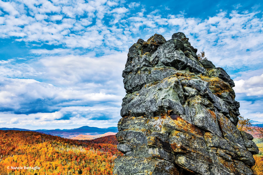
View from Kipp Mountain. Photograph by Carl Heilman II
When Fred Monroe was a kid he would take guests at his parents’ cottages on Loon Lake up nearby Stewart Mountain for a quarter. Now that easy hike on private land is free, thanks to an ambitious project spearheaded by the former town supervisor. Monroe saw the runaway success of the Saranac Lake 6er program, which combines more than 30 miles of existing trails on state land near that village; people who complete all the hikes earn a patch (see “Patch Work”). He wanted to bring that tourism boost to his own backyard. But there was a catch.
“We’re in a different position in the town of Chester,” Monroe said. “There just isn’t much state land here, only about two percent.” So he rallied the town board and community to enlist private landowners to make their mountains accessible. “They were very agreeable. Each situation is slightly different, with revocable licenses for the trails, and we hope to have permanent easements eventually,” he said.
Dan Smith, data collector for the town assessor’s office, was the boots on the ground for the project. He knows the land from a personal and professional perspective, and has been building and maintaining trails around Pottersville, Brant Lake and Chestertown for years.
“In my job for the assessor I don’t often get smiles from landowners. But this project had people just beaming,” he said. It also led to an additional title for Smith: trail coordinator.
“Landowners were willing to take a chance to share the land they love,” Smith said. Trails were developed in partnership with them, selecting routes that would minimize impact to their woodlands and also would provide great experiences for visitors. The goal was to offer a selection of easy to moderate hikes, most leading to viewpoints that few out-of-towners would have experienced before.
The background for the project came from a recreational plan prepared by Tracey Clothier, of the LA Group, who suggested 25 options for hiking, biking and paddling. Monroe and Smith researched these and narrowed down the list to the present eight trailheads, which incorporate existing ones at Dynamite Hill, Palmer Pond and Natural Stone Bridge and Caves. In just eight months deals were formalized, trails designed and parking areas created by volunteers, town employees and county work crews. A grant from the state health department administered by Glens Falls Hospital funded descriptive signs and maps on trailheads and summits. The Chester Challenge went live in October 2015, with cumulative elevation gains of 1,175 to 3,044 feet and distance totals of 10 to 30 miles, depending on the destinations chosen.
So far, more than 500 people have earned pins by completing at least six hikes. What really surprised Smith was the number of times the trails were used in 2016, based on the 21,934 names signed on registers. “This project is pulling people from all over and they’re coming back again and again, summer and winter, to hike another trail,” he said.
Smith loves the panoramic scene atop Green Hill, where he’s been for sunrise, sunset and every time in between. “You look directly at the High Peaks—Gothics, Basin and Armstrong Mountains—and can see as far south as Saratoga,” he explained. “It’s almost a 360-degree view from the top.”
Monroe’s favorites on the list are Stewart and Kipp Mountains. Kipp has a broad boulevard of a trail that climbs gently to a dramatic overlook. You’d never know there was a plunging cliff on this peaklet. It’s lightly screened by trees as you near the vista platform, though it’s best to keep a close eye on the kids and dogs so they don’t tussle near the edge.
Kipp Mountain Tree Farm owner John Sullivan said, “The most bang for the buck can be had on Meade and Beckman Mountains. The trail is initially steep, but offers five overlooks that box the compass. They are all nicely executed, with signs identifying peaks, plus amenities such as benches and picnic tables.”
The Chester Challenge
This year, plans are to create a kiosk at the municipal center with maps and brochures, and trail information is also available at the North Warren Chamber of Commerce, at Dynamite Hill. The brochure can be downloaded at www.townofchesterny.org.
After finishing six hikes, collect your bling at the town hall, North Warren Chamber of Commerce or the Crossroads Outdoors store, on Dixon Road.
On June 3, National Trails Day, there’s a work party for volunteers. Chester Challenge in a Day is July 8; if you’re feeling ready for a real workout, you can do all the trails consecutively for a special pin. Last year two men did the maximum distance of 30 miles in less than 12 hours.
Chester Creek Trails
1.2 to 1.9 miles, less than an hour
This mellow, mostly level stroll along wetlands is a good warm-up to the more strenuous trails of the challenge. Wildflowers are abundant in late spring, along with warblers and other songbirds.
Parking: Town of Chester Municipal Center on Route 9.
Cougar Nature Trails
0.9 miles to 4.5 miles, 45 minutes to 3 hours
Choose a short and steep trek to the top of Cougar Mountain or meander gradually upward. These loop trails pass through woods and fields with plenty of wildlife and picnic spots.
Parking: North Warren Central School on Route 9. Park near the tennis courts.
Dynamite Hill and Caroline Fish Memorial Trails
0.7 to 9 miles, 40 minutes to 5 hours
The town’s all-season recreation area, Dynamite Hill, offers skiing, snowshoeing and skating in winter and hiking and single-track mountain biking the rest of the year. This route connects with the Caroline Fish Memorial trails, adding more miles of easy walking.
Parking: Route 8, 2 miles west of Northway Exit 25 for Dynamite Hill, with Caroline Fish trailhead on Landon Hill Road.
Palmer Pond Trail
1 to 3.2 miles, 40 minutes to 2 hours
This Forest Preserve trail was incorporated into the challenge in 2016. The main route goes to 31-acre Palmer Pond; take short spur trails for additional views or fishing.
Parking: End of Palmer Pond Road, about a mile west of the intersection of Routes 8 and 9 near Loon Lake.
Meade and Beckman Mountains
2.1 miles, 2 hours
Climb Meade, with a few steep pitches, for an excellent view of Gore Mountain; descend a little to catch the connector to Beckman’s summit, where you can see numerous peaks to the north and east.
Parking: Igerna Road about .75 miles west of Route 9.
Kipp Mountain
1.9 miles, 2 hours
The wide trail winds and climbs through a working tree farm, and cliff faces offer surprising open vistas of Loon Lake. A wooden platform near the summit is a nice picnic spot.
Parking: Ben Culver Road, about a mile west of Landon Hill Road.
Stewart Mountain
0.8 mile, 45 minutes
An easy hike with a few steep spots leads to an open, rocky summit with great views of Gore and Crane Mountains, with Loon Lake shimmering below.
Parking: White Schoolhouse Road about a mile north of Routes 8 and 9 at Loon Lake.
Catamount Mountain and Green Hill
1.8 to 6.4 miles, 1 to 4 hours
More pain, more gain defines these trails. From Green Hill—despite its name, the most strenuous climb of the challenge—you can see the High Peaks and south toward Lake George. Access is through Natural Stone Bridge and Caves, with an admission fee ($14.95/adults, $8.50/children, kids four and under are free) when the attraction is open; the price includes these trails plus the caves.
Parking: Natural Stone Bridge and Caves, off Route 9 in Pottersville.